Marin County, California

IMG_6304

The cradle of mountain biking is just across the Golden Gate Bridge from San Francisco.  The mountain bike pioneers used to race down the Mt. Tamalpais in Marin County.   So, you would expect this area to be a mountain bike mecca nowadays.  It is a very nice, relaxed area with beautiful beaches, like Muir Beach and Stinson Beach, but it is not a mountain bike hot spot.  To a certain degree this is due to Marin County’s opinion about allowing mountain biking on single track trails.

The best ride in the area is most likely Camp Tamarancho a few miles northwest of San Raphael with purpose built trails.  Camp Tamarancho requires usage fee (day pass 5$).

I enjoyed my ride on the Diaz Ridge Trail down to Muir Beach.  Starting from Mill Valley there are various options to get up to the top of the trail. Cruising through the coast hills and down to the beaches with a fresh ocean breeze in the face lets you breathe the relaxed atmosphere there.   The Diaz Ridge Trail is a bit over 3 miles long, but there are several options to make it a loop and a longer ride.

IMG_6272

Tahoe Rim Trail & Flume Trail, Nevada

IMG_6249

The Tahoe Rim & Flume Trail is a legendary MTB-ride through fascinating nature with stunning views.  It is best done as shuttle ride starting at Tahoe Meadows on the Tahoe Rim Trail (shuttle services are available in Incline Village).

The trails are mostly smooth and easy, but the rocks and boulders add spice, particularly on the TRT.  Jumping down boulders is fun, but in the uphill sections the rocks cause some challenges.  Perhaps the biggest challenge on the Flume Trail is to keep the eyes on the trail despite the stunning views.

The Tahoe Rim Trail circles the Lake Tahoe but not the entire trail is open for bikes. The part of the TRT in this ride is open to bikes only on even numbered days and quite some traffic (hikers and mountain bikers) should be expected during the summer months.

I loved the ride on the Rim Trail with all the rock steps up and down providing little kicks to the smooth trail.  The ride on the Flume Trail was to me a sort of nature theatre.  The lower half of the Flume Trail and the section around Marlette Lake is on dual-track and less exciting.  Altogether the 40 km / 25 miles long ride is experience no mountain biker should miss.


McKenzie River Trail, Oregon

IMG_6067

The McKenzie River Trail is usually found at the top in the rankings of the best MTB trails.  For good reason.  It is a 40 km (25 miles) singletrack trail following a roaring mountain stream through pristine nature across lava flows and lush old grown forest. Ideally, it is done as a shuttle ride.

It was my 4th time that I did the MRT and it was still a fascinating experience.  At the beginning I stayed on the western side of Clear Lake.  The trail there is much smoother than the lava rock strewn trail on the eastern side.  I wanted to avoid flat tires from the sharp rocks and save some energy, as I knew from my previous rides that it is challenging to keep up the concentration level for the whole distance. The MRT requires precise steering to manoeuver around the lava rocks and the big roots of giant trees.

The first half is technically more demanding, particularly in the old lava flow areas and in the proximity of the waterfalls.   The McKenzie River suddenly disappears for quite a while and continues subterranean in lava tubes.  After all that river roaring I found the silence amazing.  Even more amazing is the azure-blue pool where the water reappears.

After the Trail Bridge Campground the trail is less technical and faster. However, the MRT might come up with a little surprise after the next turn…

Bend – Mountain Bike Eldorado in Central Oregon

IMG_5930

Bend is a real mountain bike eldorado with countless options to combine the numerous trails that were mostly built by mountain bikers.  It is flow country!  The trails are extraordinary smooth except for the sections that run across old lava flows.

The Funner-Tiddlywinks Loop is an outstanding fun ride that can be done in both directions.  I think it is better to go up Funner and do Tiddlywinks as downhill in order to enjoy all those berms and jumps.  Adding the Storm King Trail back in direction Bend is a blast that adds up to a total of 35 km singletrack trail fun.

IMG_5960


Another ride I would like to recommend is a real epic one that combines a bunch of typical Bend trails and adds up to 54 km (= 34 miles) and 1000 meters of elevation gain.  Ideally, you start at Skyliners Rd. on Ben’s Trail and connect to Skyliner Trail that brings you to Tumalo Falls.  The North Fork Trail is a strenuous hill climb alongside the river with awesome views.  From the beautiful Happy Valley you connect to the Mrazek Trail that winds down like giant slalom to Shevlin Park.  Just before reaching Shevlin Park there are only a few hundred meters on a forest road to reach the connector trail that brings you back to Skyliners Rd.

IMG_6027 IMG_6005
IMG_6010

Portlandia – Mountain Biking in the Portland (OR) Area

Portland itself is not exactly a mountain biking mecca, however, the Rose City is somehow bike savvy.  A good example to underline this is the Bridge Pedal event with all bridges are closed down for motorized traffic.  And I have to admit that I am somewhat biased, as I still feel at home in Portland.

PDXbridgepedal

Portland has the largest park in the US within the city limits, however, mountain biking is not allowed in Forest Park with the exception of some rather boring fire roads.  So, Portlanders have to drive minimum 30 – 90 minutes to get to the really good mountain biking spots.  There are magnificent trails in the Cascade Range around Hood River and Mt. Hood and in the west in the Coast Range  but as well northbound e.g. in the Mt. Saint Helens area.

IMG_5881

IMG_5843

The Sandy Ridge Trail System is located in the foothills of Mt. Hood just a few miles east of Sandy.  The trails are purpose built and offer lots of fun with countless berms and jumps.  The uphill is an easy spinning workout on a paved road.  After an elevation gain of about 500 meters there are various trail options with different skill levels, but all with great flow and fun.

The “Follow the Leader” trail is rated double diamond and has quite some challenges and rough rocky sections in the first half.  The second half has more flow and several bumps that are good for some airtime.

IMG_5714

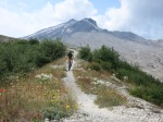
The Ape Canyon Trail up to the Plains of Abraham on Mount Saint Helens is a unique experience due to its special history.  Mt. Saint Helens is the volcano that errupted in 1980 and literally blew up its top 400 meters.  A part of the peak came down as pumice and ash and formed the Plains of Abraham – a lunarlike landscape.  It is one of my favorite rides because of the breathtaking landscape and views and the fun surfing down the pumice and zipping down the flowy singletrack trail.  From the trailhead near Lava Canyon the ride starts with strenous uphill through a stretch of old grown forest that has survived the erruption while mud and lava flows to left and right have taken away any other vegetation.  At the top of the trail spectacular views are waiting and the ride across the Plains of Abraham begins.  After half circling the Mt. Saint Helens crater to Windy Ridge there is either the option to continue down to Smith Creek for an epic loop or to turn around and enjoy the Ape Canyon Trail as a zippy downhill.

IMG_5724

IMG_5751

VIRB Picture

Seattle Area – Tiger Mountain Loop

IMG_5648

There is a lot of water in and around Seattle.  And after a day of paddling and swimming in Lake Union I felt more than ready for a bike ride.

Just a half hour drive from Seattle the Tiger Mountain Loop takes off right from the busy Hwy 18 to Snoqualmie and is considered the best ride in the proximity of Seattle.

The first part is only about gaining 640 meters of elevation on a forest road up the Tiger Mountain Summit.  The reward for the unspectacular climb is a long fun downhill trail.  Particularly the upper section that starts at the summit that was added recently is zippy and pure fun.  It winds down like a pump track that lets you fly down the hill with great flow and some airtime.  The Summit Trail connects to the Preston Railroad Trail which is a little more rugged with roots and rocks, however, all rideable and still with good flow especially in the lower section.  The timberline trail that offers great views takes you back to the trailhead through a lush old forest.

There are other good mountain biking spots like Duthie Hill, Soaring Eagle Loop or the Tapeworm Trails near Renton that are closer to downtown Seattle, however, Tiger Mountain is a real all-mountain adventure…

IMG_5587

IMG_5594

IMG_5605

IMG_5655 IMG_5638